Online Magazine
Recent Posts
- Safeguard your Cellphone Photos
- Black & White to Color – Instantly
- Wearing Many Hats
- Video Roundup
- Rescuing Your Blurry Pictures
- Showing Their Age
- What is Your Angle?
- Panorama Photos
- Humorous Photos
- Close Ups
- Fisheye Pictures
- Photo Antiquities
- Printing Big
- Appreciating Scale
- Celebrity Sightings
Tags
More Places to Go
- Free "How-To" Books “How To” books for popular cameras 0
- Vist Us on Facebook keep in touch with us on Facebook 2
Archives
- July 2023 (1)
- March 2023 (2)
- February 2023 (1)
- December 2022 (1)
- October 2022 (1)
- September 2022 (8)
- August 2022 (9)
- July 2022 (1)
- June 2022 (1)
- June 2021 (1)
- May 2021 (1)
- March 2021 (5)
- February 2021 (4)
- January 2021 (2)
- April 2019 (1)
- March 2019 (1)
- February 2019 (1)
- October 2018 (2)
- April 2018 (1)
- March 2018 (4)
- February 2018 (1)
- November 2017 (1)
- August 2017 (1)
- June 2017 (1)
- April 2017 (1)
- March 2017 (5)
- February 2017 (2)
- January 2017 (1)
- October 2016 (1)
- September 2016 (1)
- August 2016 (1)
- July 2016 (1)
- May 2016 (1)
- April 2016 (1)
- March 2016 (2)
- February 2016 (1)
- January 2016 (2)
- December 2015 (1)
- November 2015 (1)
- October 2015 (3)
- April 2015 (1)
- March 2015 (5)
- February 2015 (1)
- January 2015 (4)
- December 2014 (2)
- November 2014 (5)
- October 2014 (2)
- September 2014 (1)
- August 2014 (2)
- July 2014 (1)
- May 2014 (1)
- April 2014 (5)
- March 2014 (5)
- December 2013 (2)
- November 2013 (18)
- October 2013 (1)
- September 2013 (1)
- August 2013 (1)
- July 2013 (1)
- June 2013 (3)
- May 2013 (1)
- April 2013 (2)
- March 2013 (1)
- February 2013 (1)
- January 2013 (1)
- December 2012 (1)
- November 2012 (2)
- October 2012 (2)
- September 2012 (5)
- August 2012 (2)
- July 2012 (1)
- June 2012 (1)
- May 2012 (1)
- April 2012 (4)
- March 2012 (1)
- February 2012 (1)
- January 2012 (3)
- December 2011 (1)
- November 2011 (3)
- October 2011 (1)
- September 2011 (2)
- August 2011 (2)
- June 2011 (3)
- May 2011 (4)
- April 2011 (8)
- March 2011 (8)
- February 2011 (10)
- January 2011 (6)
- December 2010 (11)
- November 2010 (14)
- October 2010 (6)
- September 2010 (12)
- August 2010 (2)
- July 2010 (4)
- June 2010 (3)
- May 2010 (1)
- April 2010 (1)
- March 2010 (2)
- February 2010 (1)
- January 2010 (1)
- December 2009 (1)
- November 2009 (2)
- October 2009 (2)
- September 2009 (1)
- August 2009 (3)
- July 2009 (2)
- June 2009 (1)
- May 2009 (2)
- April 2009 (1)
- March 2009 (2)
- February 2009 (1)
- January 2009 (3)
One way to overcome boredom
17th November 2010
Flying can be boring, especially if I’m on a long flight. I mean, after reading the in-flight magazine isn’t there another 3 hours left to kill until I reach my destination? Sure I can take a nap, but it’s just a short cat nap – I’m frequently awakened by the pockets of turbulence along the way.
Here’s one way that I’ve managed to stay occupied during a long flight. Since my early school days, I’ve been interested in geography. I’ve combined this interest with another one – photography. When the clouds aren’t obscuring the earth, I often take pictures of the amazing scenes below.
When flying over cities, it’s usually easy to pick out familiar landmarks – skyscrapers, bridges, stadiums, rivers. But as the plane leaves these familiar environs, it becomes increasingly difficult to know what’s down there.
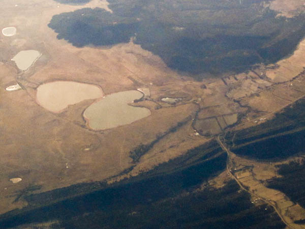
Here’s a photo that I took about 30 minutes into a recent flight from Phoenix to Chicago. As you can see, these are a small group of lakes adjacent to forested land. Knowing only the departure time (30 minutes), general direction of the flight (northeast from Phoenix) and approximate speed of the aircraft (about 500 knots), I would have a difficult or impossible task trying to determine the name and location of these lakes. |
 |
Here’s how I solved this problem. Being somewhat of a gadget freak, I picked up a small GPS device to use as a photo accessory. When used, it continuously records your geographic coordinates. So as I’m flying, it tracks the flight path of the aircraft. Since digital cameras have a built-in calendar and clock, when you take a photo, the date and time is recorded as part of the image data – its timestamp. Using included software, the timestamps of the photos are matched to the timestamps of the GPS recordings to determine the geographic coordinates at which the photo was taken. |
 |
|
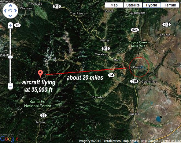
This same software, in conjunction with Google maps has me looking for a body of water 20 miles away. I found that this is Lake Cuerva – east of Santa Fe, New Mexico. For the more technically oriented, here’s more details: the pilot tells me that the aircraft flying at 35,000 ft (7 miles high) above the earth. If I hold the camera at a 45 degree angle and take a photo, that landmark is 35,000 ft away from the point directly beneath the aircraft. For this picture I was holding the camera at a 60 degree angle so the lakes are about 20 miles away. [tanget of 60 degrees is .32; therefore the distance is 35,000 ft / .32 ~ 110,000 ft ~ 20 miles]. |
 |
|
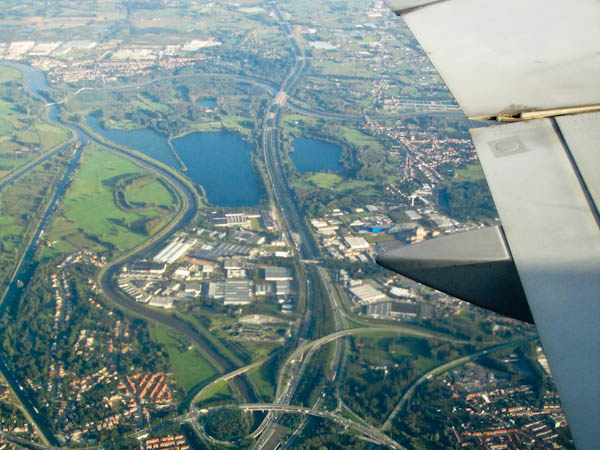
Here’s a final example. On a flight to Europe the aircraft was preparing to land in Brussels. As I was unfamiliar with the area, I relied on the GPS. Using the above technique I was able to determine that this was the town of Regulaar, Belgium. |
 |
A couple of tips for taking photos from up high:
Fly during the day. If you have a night flight, you’ll be limited to taking photos of bright lights over large cities.
Ask for a window seat and then pick one that is on the shady side of the aircraft. This is important since glare of the sun will make it very difficult to take a photo.
Many times the skies will be full of haze. The haze reduces the contrast and clarity of the photos. You can use editing software such as Picasa, Photoshop, etc to improve the images.
There’s not much you can do about clouds. Wish for a flight with clear skies.
I hope that I didn’t bore you.
NOTE: The device that I used is the PhotoTrackr model CD111. The PhotoTrackr comes with rechargeable battery, USB connection cable, charger and software to synchronize your photos to the device. It’s available from GisTEQ. Stay Focused has no connection to GisTEQ.