Online Magazine
Recent Posts
- Safeguard your Cellphone Photos
- Black & White to Color – Instantly
- Wearing Many Hats
- Video Roundup
- Rescuing Your Blurry Pictures
- Showing Their Age
- What is Your Angle?
- Panorama Photos
- Humorous Photos
- Close Ups
- Fisheye Pictures
- Photo Antiquities
- Printing Big
- Appreciating Scale
- Celebrity Sightings
Tags
More Places to Go
- Free "How-To" Books “How To” books for popular cameras 0
- Vist Us on Facebook keep in touch with us on Facebook 2
Archives
- July 2023 (1)
- March 2023 (2)
- February 2023 (1)
- December 2022 (1)
- October 2022 (1)
- September 2022 (8)
- August 2022 (9)
- July 2022 (1)
- June 2022 (1)
- June 2021 (1)
- May 2021 (1)
- March 2021 (5)
- February 2021 (4)
- January 2021 (2)
- April 2019 (1)
- March 2019 (1)
- February 2019 (1)
- October 2018 (2)
- April 2018 (1)
- March 2018 (4)
- February 2018 (1)
- November 2017 (1)
- August 2017 (1)
- June 2017 (1)
- April 2017 (1)
- March 2017 (5)
- February 2017 (2)
- January 2017 (1)
- October 2016 (1)
- September 2016 (1)
- August 2016 (1)
- July 2016 (1)
- May 2016 (1)
- April 2016 (1)
- March 2016 (2)
- February 2016 (1)
- January 2016 (2)
- December 2015 (1)
- November 2015 (1)
- October 2015 (3)
- April 2015 (1)
- March 2015 (5)
- February 2015 (1)
- January 2015 (4)
- December 2014 (2)
- November 2014 (5)
- October 2014 (2)
- September 2014 (1)
- August 2014 (2)
- July 2014 (1)
- May 2014 (1)
- April 2014 (5)
- March 2014 (5)
- December 2013 (2)
- November 2013 (18)
- October 2013 (1)
- September 2013 (1)
- August 2013 (1)
- July 2013 (1)
- June 2013 (3)
- May 2013 (1)
- April 2013 (2)
- March 2013 (1)
- February 2013 (1)
- January 2013 (1)
- December 2012 (1)
- November 2012 (2)
- October 2012 (2)
- September 2012 (5)
- August 2012 (2)
- July 2012 (1)
- June 2012 (1)
- May 2012 (1)
- April 2012 (4)
- March 2012 (1)
- February 2012 (1)
- January 2012 (3)
- December 2011 (1)
- November 2011 (3)
- October 2011 (1)
- September 2011 (2)
- August 2011 (2)
- June 2011 (3)
- May 2011 (4)
- April 2011 (8)
- March 2011 (8)
- February 2011 (10)
- January 2011 (6)
- December 2010 (11)
- November 2010 (14)
- October 2010 (6)
- September 2010 (12)
- August 2010 (2)
- July 2010 (4)
- June 2010 (3)
- May 2010 (1)
- April 2010 (1)
- March 2010 (2)
- February 2010 (1)
- January 2010 (1)
- December 2009 (1)
- November 2009 (2)
- October 2009 (2)
- September 2009 (1)
- August 2009 (3)
- July 2009 (2)
- June 2009 (1)
- May 2009 (2)
- April 2009 (1)
- March 2009 (2)
- February 2009 (1)
- January 2009 (3)
Where am I (photographically speaking)?
09th September 2010
Note:
Two years ago when I originally wrote this article, sales of GPS Navigation devices were in high gear. Most of you already know how a GPS device works:
- receives multiple satellite signals
- determines the geographic location by 3D triangulation
- displays your position superimposed on a map on its small LCD screen
- accepts your desired destination
- provides driving turn by turn instructions to reach the destination
I was interested in adding location data to my snapshots – “geotagging”. Geotagging is equivalent to performing steps 1. and 2. I found my geotagging solution in the reasonably priced PhotoTrackr.
After synchronizing the PhotoTrackr with your camera’s timestamp, it’s quite simple to use. When you’re ready to take pictures, simply power on the PhotoTrackr and it starts to record your geographic location every few seconds. When you’re done taking pictures, power the device off. When you transfer your images to your computer you also transfer the data from the PhotoTrackr. The included PhotoTrackr software matches the timestamp of the photo with the timestamp of the geographic location data and displays thumbnails overlaid on a map. Cool. The software then updates your images with the additional geotag information.
Yesterday I retrieved the yellow GPS device from the bottom of my camera bag to make sure that it is in working order since I’m getting ready to repeat this itinerary in a few days. I found that it’s still AOK after two years of reliable service. I also googled “PhotoTrackr DPL700” and found that this device is available from several places (Adorama, B&H, Amazon) for about $69. Following is the original article.
Written:September 2008.
Last week I returned from a short business trip to Europe. As is my usual custom, a camera accompanied me. But I also stuffed a small gadget into my carry-on bag.
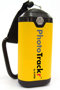 |
The PhotoTrackr is small and colorful – about the size of a salt shaker. As it’s name suggests, it helps you keep track your photos. The PhotoTrackr is a minature GPS receiver. Turn on the little device when you’re taking photographs and it records your physical location to its built-in flash memory. Later, you transfer this information to your PC or MAC with the included software to match the GPS timestamp to the timestamp on each of your digital photos. By geotagging your photos, you can instantly recall where each photo was captured.
Since this five day jaunt to Europe was my first extended travel with the PhotoTrackr, I was anxious to give it a workout. The first stop was England and my first opportunity to check it out was when I hopped on the Underground for a trip from Heathrow Airport to central London. |
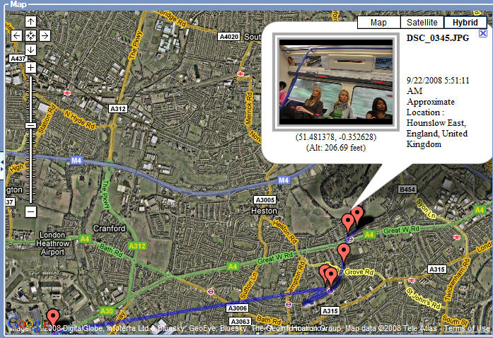 |
Here the PhotoTrackr software displays the subway trip in dark blue and and identifies my photos as red pushpin icons. It displays the mapping information using Google Earth – choice of Map, Satellite or Hybrid (a combination of the two). When you hover the mouse over one of the pushpins, the software displays a thumbnail of photos taken at that particular location. |
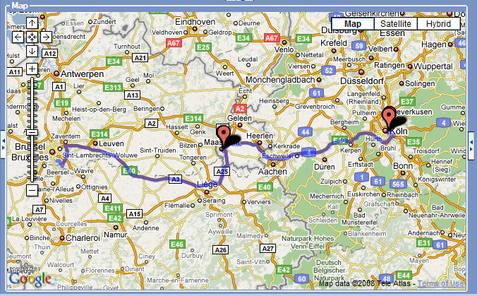 |
My next stop was Cologne, Germany. You can see that I tracked the return trip by car from Cologne to Brussels, a distance of about 200 kilometers. |
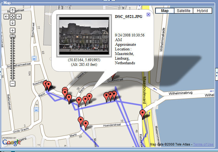 |
The trip back to Brussels is an easy one via the autobahn. We stopped for coffee in Maastricht. You can’t tell from the map above, but there are multiple pushpins near Maastricht. Enlarge the map and more detail is revealed. You can now see the path along which we walked in the old town area as we took various pictures of this Dutch city’s lovely architecture and riverfront. |
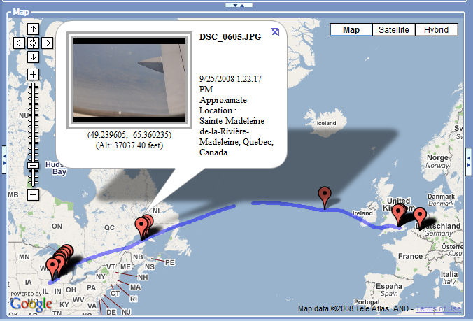 |
My return took me from Brussels to Chicago with a transfer of planes in London. For the trip home, I turned on the PhotoTrackr to see if it would track my flights. You can see that the little GPS receiver did a fine job. Notice the the break in the blue path line near Greenland. Here I had to temporarily turn the PhotoTrackr off to change its single AA battery. You can also see a thumbnail of a photo that I snapped while over the eastern Canadian coastline. |
All in all, I’m happy with the results that I’ve had from the PhotoTrackr. Another advantage of the PhotoTrackr is that I can use it with any camera that records EXIF data (almost all of them). You might call it an apolitical photo device. I’ve geotagged photos taken with Canon 5D, Canon XSi, Canon 40D, Nikon 700, Nikon 90 and Olympus 1030. One slight problem is that the battery compartment cover no longer closes fully. I am using a small piece of duct tape to keep it closed. The GisTEQ customer support staff – the maker of the Photo Trackr – has promised to send me a no-charge replacement cover.
I picked up the PhotoTrackr Lite – DPL700 via the Internet from Adorama in New York City for about $95. For more information see the GisTEQ website.
It looks as if geotagging will become more common in the future. Already cameras such as the Nikon P6000, Samsung HZ35W and Panasonic DMC-ZS7 have built-in geotagging. And many mobile devices such as the iPhone, Droid or others automatically add geotagging data to your photos. If you would like to easily add geotagging information to your pictures, an easy-to-use device such as the PhotoTrackr can do the trick regardless of which camera you use.