This “western” style town is a short thirty minute drive from downtown Reno.
A very winding road takes you about 1500 feet above Reno where you’ll have a view of the attractive high plains landscape.
Then you’ll immediately see the town’s historical likeness to a mining town of the past.
One of the first sites you’ll see is the tall, picturesque St Mary in the Mountains Church.
The town maintains the look of the 1800s having storefronts with wooden sidewalks.
There are plenty of shops lining the narrow streets in town.
Inside candy is sold the “old” way from these barrels.
… and they have plenty of souvenirs available that date from earlier decades
Collectors will find plenty of items that might appeal to their liking
We stopped for lunch at one of the many local restaurants – this one with a very interesting name.
And our favorite BBQ was on the menu,
And of course there was time for a little humor remembering the early days of law and order in the old west.
My son often visits this shop for beef jerky. Watch out for fire!
The town was founded in the 1850’s as a mining town because of the discovery of gold and silver known as the Comstock Lode. By the late 1800s the output of the mines fell of and the large population declined.
Some of the older readers may remember a western television program from the 1960s and 1970s called Bonanza. The Cartwright Family owed the fictitious Ponderosa Ranch located near Virginia City.
If you’re in the Reno area, take a ride to see the charm of an old western town.
As I was driving south on US-95 from Beatty, NV back to Las Vegas I saw this sign.
The name of the place was interesting so I took the exit.
Mercury has a name that is truly unique.I spotted this sign after visiting Death Valley National Park on the highway returning to Las Vegas.
Driving a few hundred yards down the exit road, I encountered this sign.
To comply with the terms of this sign I turned my car around, got back on the highway and made my way back towards Las Vegas.
The sign had already peeked my interest so when I got back to the hotel I did a little research about this place. Here is what I learned.
It’s suspected that mercury was discovered in the surroundings in the mid 1800s and the miners used a road through the area to reach the mines, thus the name. Characterized as a wasteland it went unsettled for a hundred years. The town sits just 5 miles from Hwy US95.
In 1950 the Atomic Energy Commission decided to develop Base Camp Mercury for atomic testing. Initially the AEC built office spaces and living accommodations for employees. Soon many more employees were needed requiring additional temporary facilities including housing, storage, schools, eating , church, banking, recreational and entertainment facilities. In 1954 Base Camp Mercury became Mercury, NV.
By the early 1960s there were more than 10,000 employees in Mercury. To accommodate the workforce the AEC undertook construction of more permanent facilities. The task of the AEC was to study and develop peaceful uses for nuclear energy. These activities continued for years but by the mid-1990s the nuclear testing was discontinued. As a result the town lost most of its population. Since then most of the facilities constructed for the workers have been demolished.
Mercury continues to be part of the larger Nevada National Security Site. Its mission is to operate multiple “facilities delivering technical and service solutions in support of national security”. The NNSS is overseen by the Department of Energy.
For reference this map shows Mercury (towards bottom) in relation to other military installations in southern Nevada. You can see that the map also shows the iconic and secretive Area 51 at Groom Lake.
Credit for this map:
By Finlay McWalter – USGS Topo mapsGIS data in NASA World WindNationalAtlasDreamland resortGroom Lake Desert RatGlenn CampbellFAA Aeronautical chartWikipedia maps of Nevada and the western USANevada DOT air transportation map The following will be corrected in a future version of this map:Indian Springs Air Force Auxilliary Field was renamed Creech Air Force Base in 2005The designation for Nevada State Route 374 should be drawn on the Nevada side of the border. The road’s equivalent on the California side, Daylight Pass Road, is unnumbered., CC BY-SA 3.0, https://commons.wikimedia.org/w/index.php?curid=310530
Due to my love of traveling I’ve made countless cross country trips by car.
Our interstate highway system gives us easy access to most of the USA. On the road, I’ll sometimes see an exit with a name that I don’t recognize. Places with colorful names stick in my mind. I’d jot down the name and when I get home search to find out about the place I passed. earlier.
Interstate 80 in Utah
Aragonite in the high desert of north central Utah is one such place. Now a ghost town, it was originally set up in the early 1900s to mine the crystalline mineral of the same name. Buildings were erected there to house and supply the miners. These mining operations lasted only a short time but later reopened to quarry mine for limestone. One report says that this mining included construction of shafts and deep holes so if you visit the area, watch your step. There is no longer is any mining in here.
A Desert Remote Locality
You can also tell that Aragonite is remote by the surrounding localities. To the west is the Utah Test and Training Range. This is a military base where supersonic flights are routinely conducted. To the southwest is the Dugway Proving Grounds an Army facility where chemical and biological weapons testing are performed.
Not far from the townsite is the Aptus Incinerator. It is used mainly for hazardous waste disposal including PCBs. The operating company is Clean Harbors which claims “ample on-site storage capacity allows for acceptance of large volumes of material before treatment. The site can also be easily accessed by rail or truck, which keeps transport costs down. And, an on-site lab assures timely approval and efficient processing of shipments.” Clean Harbors has been cited multiple times for violating EPA regulations.
Sometimes places are deliberately remote to keep people away from them.
I found that aside from its interesting name Aragonite’s history and surroundings are a worthwhile stop the next time I’m in Utah.
Still Interested
More of my places that you may never have heard of are in
Places that you may have never heard of
Friends know that I’m a big fan of traveling and do so frequently by car. Whether I’m visiting relatives who live far away or I’m vacationing at distant places, it’s usually a cross country trek.
Anyone who has traveled on our extensive road system has driven past signs denoting names of places of which they’ve never heard. Those places that especially stick out to me are ones that have colorful names. One of my “hobbies” is to note these names and later (sometimes weeks, sometimes months later) find out more about these places.
One of these places is Argenta, Nevada and this is what I learned.
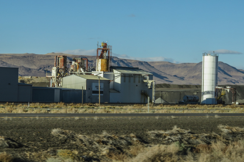
Argenta is a ghost down in central Nevada. In the mid 1860’s prospectors discovered silver in the area. The town was planning to develop as a shipping center for the nearby mines and in Austin to the south. However, the town of Battle Mountain had stronger ties to the silver industry and by 1871 the entire town moved to Battle Mountain making Argenta effectively a mining ghost town.
Argenta remained vacant until 1930 when barite was discovered nearby. This mine in Argenta Mountain was operated by the Baker Hughes Company until it closed in 2015.
One of the Baker Hughes operations alongside a railroad siding and Interstate 80
Well, that’s the short story about Argenta, NV.
Yet curiosity remains high and I hope to report on other interesting names of places that are part of my hobby.
More of my places that you may never have heard of are here